Smart Industry: How do you define reality modeling?
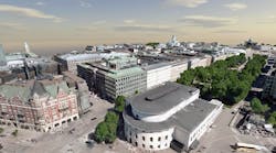
Francois: Capturing the existing condition in support of solving different business problems in design, construction, operations, inspection and modeling. It’s a 3D representation of the real world, using the Bentley software ContextCapture, which can take normal photos and turn them into 3D models of reality. We can scale from a fire hydrant to an entire city. Take Helsinki as an example [image below]. We processed 55,000 images at high resolution, then scaled out at multiple machines.
Smart Industry: What are the applications for reality modeling?
Francois: Say you are modeling an intersection…you want to capture the existing conditions to get the proper context, to get the right design. You can learn what you need to move, add, redesign to get the new reality created. Once design is done we go into construction, when reality modeling is used to track progress. You can get a snapshot in time of the current situation, a real-time benchmark of progress.
Smart Industry: How is the digital transformation affecting reality modeling?
Francois: During the image-capture phase you need good cameras and cheap drones. Next, the availability of cloud computing enables the graphic-computing. We are now capable of using laser-scanning, which is more accurate than photos from a drone. The last element is implementation—imagine that you’re using Microsoft Hololens. This is all transforming the workplace.
Smart Industry: What are the most common current uses of reality modeling?
Francois: 3D mapping of cities—we’ve done Helsinki and Paris—for design-planning or remodeling neighborhoods. The real-estate market will use this. Solar-panel programs will rely on this. And consider plant buildings, water-treatment plants and oil refineries using reality modeling. We can now see inside of plants, which in some cases had been difficult to access.
Smart Industry: We’ve heard throughout this conference that “reality modeling is going mainstream.” What does that mean?
Francois: Users are adopting this technology, from construction foremen to bridge inspectors to civil engineers to operations technicians. We know it’s a new field. We have a sub-company in charge of working with users to get them started.
And from the technology angle, Bentley tools are being adapted to work with reality meshes (3D representations of reality in triangulated forms) by practitioners who are demanding this data. The technology to capture these models is getting cheaper and cheaper, and cloud technology is democratizing the process.
Smart Industry: What most excites you about reality modeling?
Francois: What I find most exciting is the development of drone technology. My dream is to use drones to accurately depict, say, a bridge in Tahiti with the finest detail. I am working toward that on a daily basis.


